SERVICES

HYDROLOGY
Hydrology is the scientific study of the movement, distribution, and quality of water on Earth, including the water cycle, water resources and environmental watershed sustainability. Using various analytical methods and scientific techniques, we collect and analyze data to help understand and solve water related problems such as water balance of a basin, agricultural water balance, mitigating and predicting flood, debris flow, landslide and drought risk, and assessing the impacts of environmental change on water resources.

HYDRAULICS
Hydraulics encompass a wide range of environmental and indu-strial applications. Using the more advanced tools for river hydraulics modelling (BASEMENT - with bed/suspended load, contaminant transport if needed), mud/debris flow (Flo2D) and for snow avalanches, we address and solve problems related to the management of the hydraulic controls, the understanding of the hydro-morphological behaviors of rivers, mapping of flood-prone areas, the hydro/thermo-peaking etc.
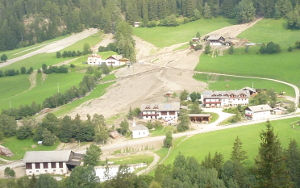
FLOOD RISK ANALYSIS
A flood risk assessment plan is an analysis of the flooding risk from all flooding mechanisms, the identification of flood mitigation measures and should provide advice on actions to be taken before and during a flood. Based on the outcome resulting from the hydraulic analysis, even taking into account climate changes, we can define the areas affected by floods, debris floods, snow avalanches etc. Depending on the type of phenomenon, we tackle the design of the measures for the flood prevention, protection and mitigation.

WATER BALANCE ANALYSIS
The management of the water resource is one of the most issues that the society must take into account. Moreover, in some areas of the earth, climate changes have a severe impact on the drinking water supply, the agriculture and the industrial water supply.
Environmental Consulting, through data field collection and mathematical modelling, provides consultancies on resources management, soil water balance and on estimation of crop water demand.

GIS APPLICATIONS
Geographic information systems (GIS) are all the tools that enable users to capture, store, analyze and manage spatially referenced data. GIS applications range in a wide of uses: remote sensing applications, environmental data mapping, survey data management.
Thanks to our knowledge (ArcGIS, QGis, Grass), we can manage all type of georeferenced data, such us land use data, soil data, perform remote sensing analysis, conduct geostatistical analysis etc.

MULTIPHYSICS SIMULATIONS
Research and engineering applications regarding multiphysics simulations have been given great attention over the last decade. Multiphysics modelling covers areas of physics, such as structure mechanics, fluid dynamics, heat transfer, electromagnetic, acoustics etc.
Using tools as COMSOL and OPEN Foam we can perform fluid dynamics analysis and studies on coupled problems such as thermo-fluid dynamics of combustion flue gas inside stoves.